Top 10 Antique Maps with Historical Significance
Maps are more than just pieces of paper with lines and shapes. They are windows into the past, offering a glimpse into how people understood and navigated their world throughout history. Antique maps tell us about geography and the mindset of the eras they belong to. Let's journey through time and explore the top 10 antique maps with immense historical significance.
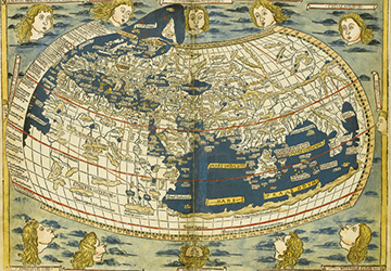
1.Ptolemy's World Map (c. 150 AD)
One of the oldest surviving maps, Ptolemy's World Map, is a testament to the ancient knowledge of the Earth's geography. Created by the Greek mathematician and astronomer Claudius Ptolemy, this map reflects the understanding of the world during the Roman Empire.
The map is centered around the Mediterranean Sea and portrays the three known continents: Europe, Asia, and Africa. While its accuracy might seem questionable today, it was a monumental achievement in its time, laying the groundwork for future cartography.
2.Tabula Rogeriana (1154)
Crafted by the Arab geographer Muhammad al-Idrisi for King Roger II of Sicily, the Tabula Rogeriana is a remarkable fusion of Islamic and European cartographic knowledge. This medieval map was created during a time when cultures were exchanging ideas.
The map incorporates geographical details from both Eastern and Western traditions, showcasing an attempt to bridge gaps in understanding between different civilizations. This knowledge exchange was a precursor to the globalized world we know today.
3.Waldseemüller Map (1507)
The Waldseemüller Map is renowned for being one of the first maps to label the New World as "America" in honor of Amerigo Vespucci. Created by German cartographer Martin Waldseemüller, this map marks a pivotal moment in the Age of Exploration.
It reflects the growing awareness of new lands across the Atlantic and the evolving understanding of the global landscape. The map's inclusion of this new continent demonstrates the excitement and curiosity that characterized the dawn of a new era.
4.Vinland Map (15th Century)
The Vinland Map is a fascinating artifact that depicts parts of North America, specifically the northeastern regions, with a label suggesting the presence of Norse settlements. While its authenticity has been debated, it highlights the Norse exploration of the Americas long before Columbus.
If genuine, it would rewrite the history of early exploration, emphasizing the significance of lesser-known journeys in shaping our understanding of the world.
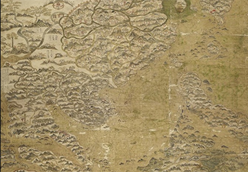
5.Selden Map (17th Century)
The Selden Map is a rare gem that provides insight into maritime trade during the Ming Dynasty in China. Created in the 17th Century, this Chinese map is not just about geography; it's a blend of art, navigation, and economic information. It showcases trade routes, commodities, and cultural exchanges between China and other parts of Asia.
Beyond geography, it vividly illustrates the interconnectedness of civilizations through trade and the importance of such exchanges in shaping history.
6.Fra Mauro Map (1450s)
Crafted by the Venetian monk Fra Mauro, this mappa mundi stands out for its intricacy and attention to detail. Fra Mauro's map was a labor of love, meticulously compiled based on the knowledge available at the time.
It gives us a glimpse into the medieval European perspective on the world, combining geographical accuracy with artistic flourishes. The map's creative elements remind us that historical artifacts are not just sources of information but also expressions of the human spirit.
7.Cantino Planisphere (1502)
The Cantino Planisphere is a Portuguese map that vividly illustrates the Age of Exploration. Commissioned by Alberto Cantino, an Italian diplomat in the service of Portugal, this map features newly discovered lands, trade routes, and intricate coastal details.
It's a snapshot of the race among European powers to stake their claims in the New World. This map captures the competitive spirit of exploration and the eagerness to document newfound territories.
8.Mitchell Map (1755)
The Mitchell Map, also known as the "Map of the British and French Dominions in North America," is a significant piece from the pre-Revolutionary War era. It was created by John Mitchell and played a role in shaping the war's outcome.
The map's detailed depiction of territorial claims and Native American tribes was used for diplomatic negotiations and strategic decision-making. This map underscores the intersection of geography and politics, showcasing how maps can influence the course of history.
9.Beatus Map (8th Century)
The Beatus Map is a medieval mappa mundi with a unique twist to illustrate Biblical events and locations. Created during a time when religion played a central role in people's lives, this map merges spiritual beliefs with geographical understanding.
It provides a fascinating glimpse into how medieval minds intertwined their faith with their perception of the world. The map's synthesis of religious narratives and geographic features speaks to the intertwined nature of belief and knowledge.
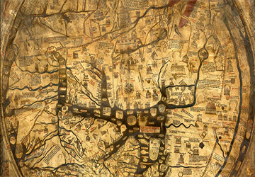
10.Hereford Mappa Mundi (13th Century)
The Hereford Mappa Mundi is a treasure trove of historical and cultural insights. This medieval map is more than just a geographical representation; it's a visual encyclopedia of the medieval worldview. It features Biblical scenes, legendary creatures, exotic lands, and a mix of natural and imagined geography.
It's a snapshot of how people of the time viewed their place in the grand tapestry of history. This map showcases the human imagination and how people seek to understand and represent their world.
The Evolution of Cartography and Its Impact on History
Maps have always been more than static representations; they have acted as dynamic tools that influence decision-making, exploration, and cultural exchange.
From ancient civilizations using rudimentary sketches to navigate their territories to the meticulously detailed maps of the Age of Exploration, cartography evolved hand in hand with expanding human knowledge.
As cultures connected and interacted, maps served as bridges between distant lands, facilitating trade, diplomacy, and the sharing of ideas. In recent times, the digital revolution has taken cartography to new heights.
Conclusion
In conclusion, these antique maps serve as more than just tools for navigation—they are windows into the past, offering us a glimpse into the evolving understanding of the world. Each map tells a story of its time, reflecting the knowledge, aspirations, and cultural exchanges of the eras in which they were created. Studying these maps gives us a deeper appreciation of the intricate relationship between geography, history, and human curiosity.